 |
|Японцы спроектировали самую точную карту Мира
Мы складываем представление о мире теми картинками, которые нам доступны с детства. Это передачи о Земле и... школьные карты. Но как оказалось, карты ошибочны! Они спроектированны больше для наглядности, нежели для научной точности. Но эта карта максимально точна!...
Authagraph World Map
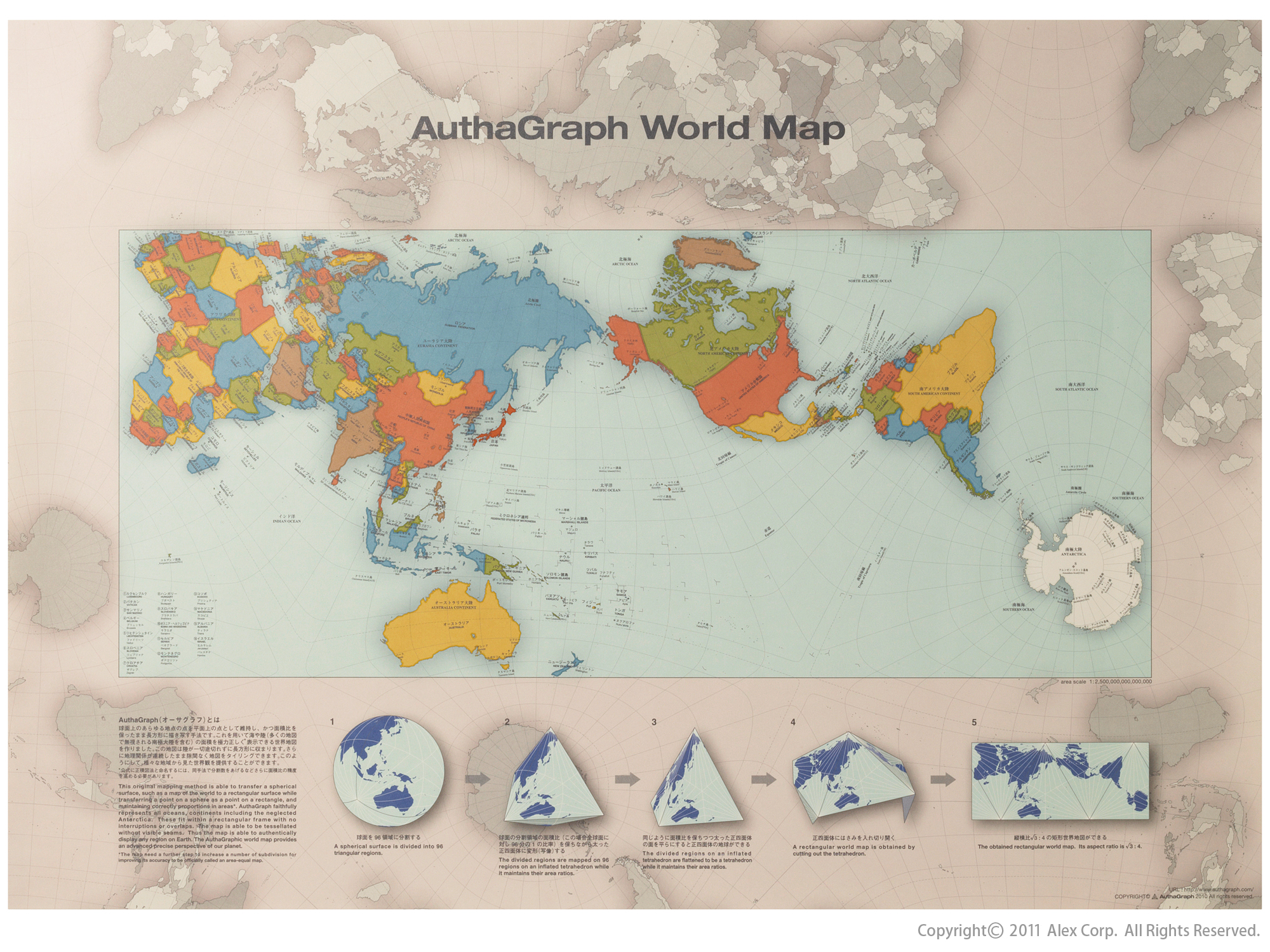
Максимальный размер: 2000x1500

AuthaGraph World Map - Antarctica was found in 1820 and the first man reaches the North Pole in 1909. In the 20th century the world tended to be framed by the East-West relations and the North-South problem. Our interest has been mainly on land since it has been our living environment. Meanwhile from the late 20th century the resources and environment problems have spread our interests over the polar regions and oceans such as, (1) Sea ice around the North pole representing the global warming, (2) Territorial sea claims for marine resources, (3) An ozone hole above the South Pole, (4) Melting glaciers in Greenland, a cause that may submerge Tuvalu, (5) El Nino in the ocean, a cause of an unusual weather that eventually influence to the economy on land. The AuthaGraphic world map aims to provide a new view point to perceive the world by equally showing these interests spread over the globe.
Многие в курсе, что привычная нам карта мира не слишком верно отражает реальное соотношение площадей стран, а тем более морей и океанов. Использование проекции Меркатора приводит к появлению множества искажений, когда, к примеру , Гренландия смотрится крупнее Австралии...
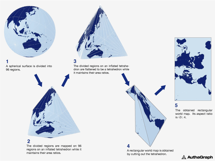
AuthaGraphic Projection - An original method for maintaining areas proportions is called "iso-area-mapping." And an original mapping process by combining different projection methods via intermediate objects is called "multilayer-mapping." These ideas for mapping aims to reduce errors during projecting a sphere to a tetrahedron because a simple optical projection from a sphere to a tetrahedron causes huge distortions therefore useless.
Принципиально новая проекция, предложенная японскими дизайнерами, позволила построить самую точную карту мира, которую когда-либо видело человечество.
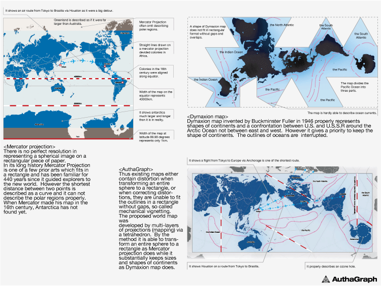
Comparison/ Rectangle or Accuracy - AuthaGraph map is able to transform an entire sphere to a rectangle as Mercator projection does while it substantially keeps sizes and shapes of continents as Dymaxion map does.
Традиционная карта мира строится старинным способом, при котором изображение с поверхности глобуса переносится на плоскую карту с использованием проекции Меркатора. Как результат, мы получаем на карте Гренландию в несколько раз крупнее Австралии, тогда как на самом деле Гренландия втрое меньше.
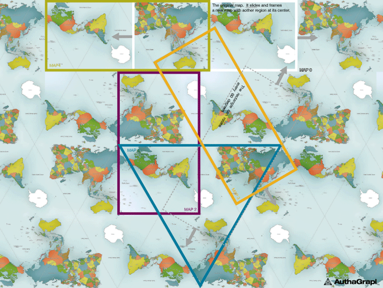
the World without Ends - It is able to tile the AuthaGraphic world map without gaps and overlaps. The way of tessellation has seamless connections between maps as if it is an Escher’s tiling. Same as fishes and birds in his painting, six continents are never fragmented and seven oceans keep their continuous networks. It had been thought the world is on an infinite plane since geometries of a sphere and of an infinite plane are similar. Walking on both surfaces, we do not meet an end. A geographical network in the map is able to expand to any directions on the tessellated maps. Thus the world map reproduces the spherical world without dead end on a plane.
А вот карта, построенная по принципам проекции AuthaGraph, может быть названа действительно инновационной! Здесь пропорции суши и воды остаются неизменными и соответствуют тому, что мы видим и на глобусе. За эту разработку компания AuthaGraph получила престижную награду – Japanese Good Design Award.
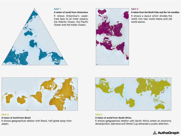
World Map Re-arrangements - On the tessellated maps it is able to frame a view field covering a full set of a world. The frame functions as a viewer which enables user to slide and rotate and then to frame a new world map with a preferable region at its center. They provide a new angle of perspective to equally view the world so as to be free from existing perceptions defined by usual phrases such as “far east”, “go up north”, “Western”.
Автор новой революционной проекции – Хаджиме Нарукава. Суть его идеи в том, что сферическую поверхность глобуса разбивают на 96 треугольников.
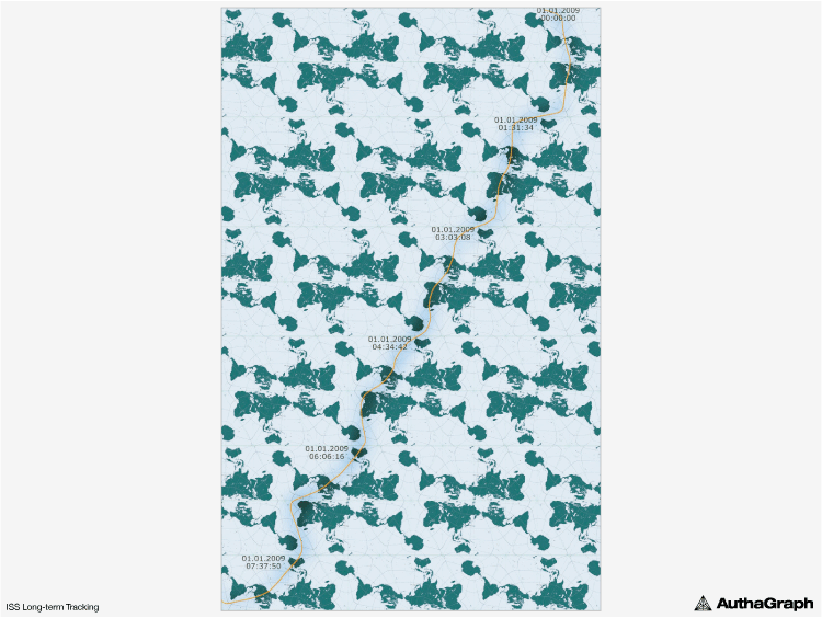
ISS Long-term Tracking - An orange line on tessellation-world composed by 49 maps tracks a journey of International Space Station (ISS) for eight hours. Its coordinates are provided by ‘Cerestrak’, a website distributing ISS’s orbital data. NASA and the US department of defense issue the original data. The coordinates are defined by calculating the data to reflect corrections of the orbit. - It has past 140 years since ‘Around the World in Eighty Days’ (Verne) was published. Satellites fly across the world in hours while they play leading roles of telecommunication and remote sensing such as observing weather, environmental pollutions and natural resources. The tessellationworld map shows such rapid movement of a satellite in one line.
Затем идет оригинальный процесс переноса изображения на плоскость путем комбинирования различных способов проецирования через промежуточные объекты. Такое "многослойное отображение" снижает число ошибок и чудовищных искажений, которые возникают при традиционном разворачивании поверхности глобуса в плоскую карту.
Via ecology.md
Created/Updated: 25.05.2018