
Сверхподробние карти місячної поверхні стали доступні всім
Місяць - природний супутник Землі. Найближчий до Сонця супутник планети, так як у найближчих до Сонця планет, Меркурія і Венери, супутників немає. Другою за яскравістю об'єкт на земному небосхилі після Сонця і п'ятий за величиною природний супутник планети Сонячної системи. Середня відстань між центрами Землі і Місяця - 384 467 км (0,002 57 а. Е., ~ 30 діаметрів Землі). Видима зоряна величина повного Місяця на земному небі -12,71m. Освітленість, створювана повної Місяцем біля поверхні Землі при ясній погоді, становить 0,25 - 1 лк. Місяць є єдиним астрономічним об'єктом поза Землею, на якому побувала людина.
Вчені з Геологічної служби США спільно з фахівцями NASA склали дві дуже докладні місячні карти.
Карти зроблені на основі даних, отриманих за допомогою автоматичної міжпланетної станції NASA Lunar Reconnaissance Orbiter.
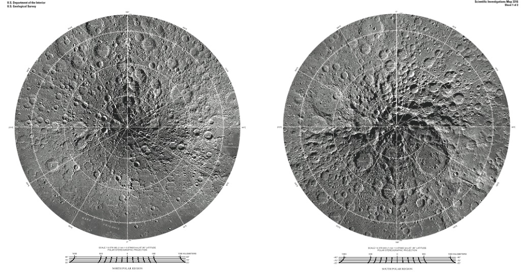
На карті, складеній з знімків ширококутної камери, розташованої на борту зонда, вказані всі об'єкти розміром більше 85 кілометрів. У надвисокому дозволі (245 Мб) карту можна завантажити тут .
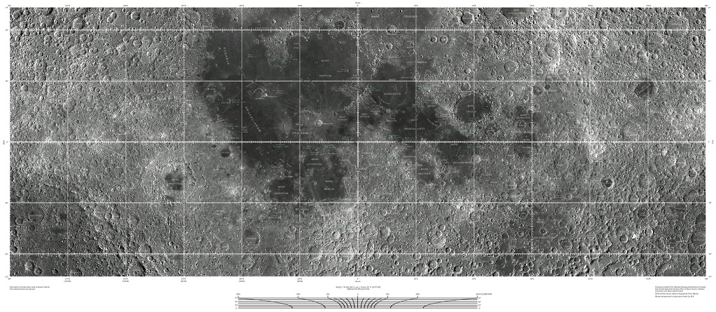
Sheet 1: This image mosaic is based on data from the Lunar Reconnaissance Orbiter Wide Angle Camera (WAC; Robinson and others, 2010), an instrument on the National Aeronautics and Space Administration (NASA) Lunar Reconnaissance Orbiter (LRO) spacecraft (Tooley and others, 2010). The equatorial WAC images were orthorectified onto the Global Lunar Digital Terrain Mosaic (GLD100, WAC-derived 100 m / pixel digital elevation model; Scholten and others, 2012) while the polar images were orthorectified onto the lunar LOLA polar digital elevation models (Neumann and others, 2010). The Mercator projection is used between latitudes ± 57 °, with a central meridian at 0 ° longitude and latitude equal to the nominal scale at 0 °. The Polar Stereographic projection is used for the regions north of the + 55 ° parallel and south of the -55 ° parallel, with a central meridian set for both at 0 ° and a latitude of true scale at + 90 ° and -90 °, respectively. All named features greater than 85 km in diameter or length were included unless they were not visible on the map. Some selected well-known features less than 85 km in size were also included. For listed references, please open the full PDF.
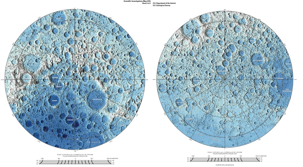
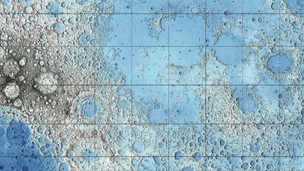
Топографічна місячна карта складена за допомогою лазерного альтиметра; при її формуванні використано понад 6,5 мільярда вимірювань, зроблених за період з 2009 по 2013 роки. У надвисокому дозволі (461 Мб) карту можна завантажити тут .
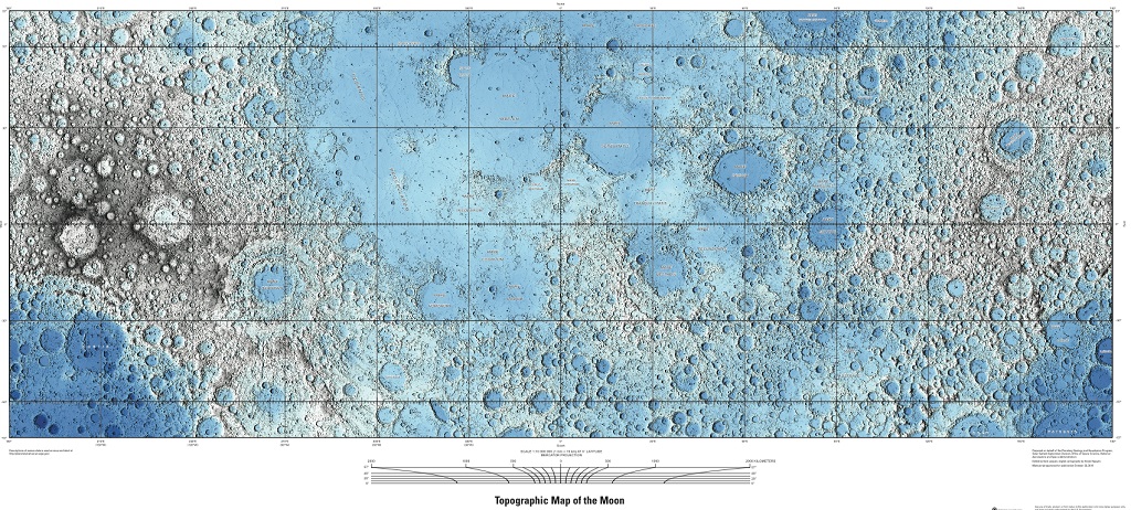
Sheet 2: This map is based on data from the Lunar Orbiter Laser Altimeter (LOLA; Smith and others, 2010), an instrument on the National Aeronautics and Space Administration (NASA) Lunar Reconnaissance Orbiter (LRO) spacecraft (Tooley and others 2010 ). The image used for the base of this map represents more than 6.5 billion measurements gathered between July 2009 and July 2013, adjusted for consistency in the coordinate system described below, and then converted to lunar radii (Mazarico and others, 2012). For the Mercator portion, these measurements were converted into a digital elevation model (DEM) with a resolution of 0.015625 degrees per pixel, or 64 pixels per degree. In projection, the pixels are 473.8 m in size at the equator. For the polar portion, the LOLA elevation points were used to create a DEM at 240 meters per pixel. A shaded relief map was generated from each DEM with a sun angle of 45 ° from horizontal, and a sun azimuth of 270 °, as measured clockwise from north with no vertical exaggeration. The DEM values were then mapped to a global color look-up table, with each color representing a range of 1 km of elevation. For this map sheet, only larger feature names are shown. For references listed above, please open the full PDF.

Коментарі
Коментуючи, пам'ятайте про те, що зміст і тон Вашого повідомлення можуть зачіпати почуття реальних людей, проявляйте повагу та толерантність до своїх співрозмовників навіть у тому випадку, якщо Ви не поділяєте їхню думку, Ваша поведінка за умов свободи висловлювань та анонімності, наданих інтернетом, змінює не тільки віртуальний, але й реальний світ. Всі коменти приховані з індексу, спам контролюється.